Great Trails within 90 Miles of the City
 I’m just going to go ahead and say it: the Philadelphia metro area has the best cycling trails in the United States. Within an hour’s drive, there are hundreds of miles of safe, car-free paved and gravel trails with beautiful scenery and interesting towns to explore.
Pennsylvania and New Jersey were industrial powerhouses in the late 19th and early 20th centuries when coal was king and manufacturing flourished, facilitating the development of riverside canals and train lines. Now those tow paths and rail beds have been converted to recreational trails, and modern cyclists are the lucky beneficiaries.
The maps below show a dozen 25-50 mile journeys that are easy to reach and provide a great way to spend a weekend afternoon or day off. They all have starting points within about 90 miles of Center City. (Admission: I would have chosen 60 miles, except that it would have excluded Jim Thorpe and the Lehigh Gorge, which is too good to leave out.)
They’re all easy rides, with minimal climbing and distances that can be varied to suit most riders’ preferences. Most also have plenty of places to stop and explore or grab a bite to eat.
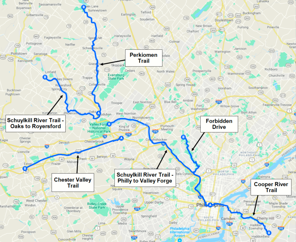
Rides from Center City
Click on the image below to open a version in Google Maps.
Details
| Trail Name | Public Transit | |
|---|---|---|
| Schuylkill River Trail – Philly to Valley Forge
Terrain: Mostly Paved |
★★★☆☆ | SEPTA Manayunk/Norristown Line |
| Schuylkill River Trail – Oaks to Royersford
Terrain: Half Paved / Half Gravel |
★★☆☆☆ | — |
| Forbidden Drive – Philly to Chestnut Hill
Terrain: Mostly Gravel |
★★★★☆ | SEPTA Chestnut Hill West Line |
| Perkiomen Trail – Oaks to Perkiomenville
Terrain: Mostly Gravel |
★★★★☆ | — |
| Cooper River Trail – Collingswood to Haddonfield, NJ
Terrain: Paved |
★★☆☆☆ | PATCO |
| Chester Valley Trail – King of Prussia to Exton
Terrain: Paved |
★★☆☆☆ | SEPTA Norristown High Speed Line |
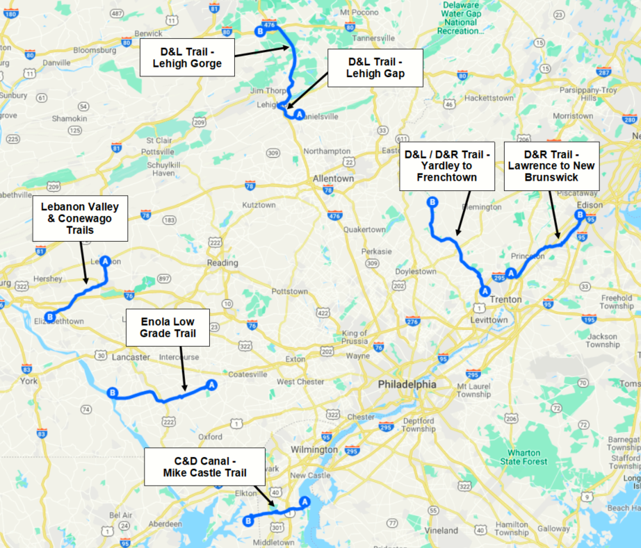
Rides Within 90 Miles of Philadelphia
The rides in this group are a bit outside of Philly, but all start within 90 miles. Some are accessible using public transportation. The others require a car.
Click on the image below to open a version in Google Maps.
Details
| Trail Name | Public Transit | |
|---|---|---|
| D&L / D&R Trail – Yardley to Frenchtown
(Note: D&R is NJ side, D&L is PA side) Terrain: Gravel |
★★★★☆ | SEPTA West Trenton Line |
| D&R Trail – Lawrence to New Brunswick
Terrain: Gravel – Some Rough |
★★★☆☆ | SEPTA Trenton Line |
| D&L Trail – Lehigh Gap (south of Jim Thorpe)
Terrain: Mostly Gravel |
★★★★☆ | — |
| D&L Trail – Lehigh Gorge (north of Jim Thorpe)
Terrain: Gravel – Some Sandy Sections |
★★★★★ | — |
| Enola Low Grade Trail – Quarryville to Susquehanna River
Terrain: Gravel Note: Despite what online and trail maps indicate, the section east of Quarryville is unrideable and the section west of Marticville Rd is closed, making a long ride very difficult. I did not attempt to reach to the section along the Susquehanna River to determine its condition. |
★☆☆☆☆ | — |
| Lebanon Valley & Conewago Trails – Lebanon to Aberdeen
Terrain: Mostly Paved |
★★★☆☆ | — |
| C&D Canal / Mike Castle Trail – Delaware City to Chesapeake City
Terrain: Paved |
★★★☆☆ | — |


Laura Kuhlman says:
This is a great way to figure out where I want to go next. I love the idea of trails without cars. Being a road rider mostly, I find getting off the “car” pavement super refreshing.
Keep the info coming!
Laura
Portland, OR